Route 1: Tenerife
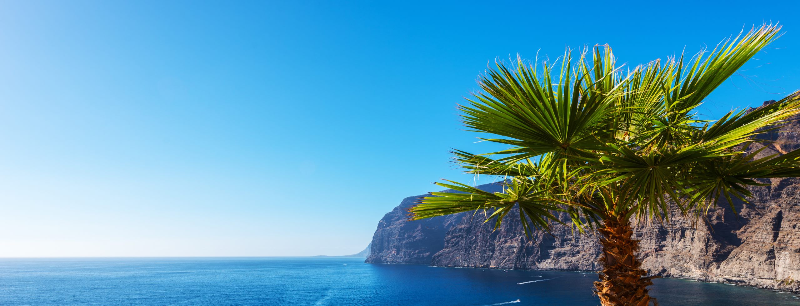
Tenerife may be the largest of the Canary Islands, but it is not just its size that attracts such a large number of the visitors annually. Tenerife owes its appeal to the diversity of both its natural and human characteristics. If you are interested in the former, the northern part is relatively mountainous and although exposed as it is to the moist Atlantic winds, is somewhat cooler, greener, and less “touristy.” The main city of Puerto de la Cruz has maintained its charm as an old port town, and has various locales and services for visitors who spend time here. The southern part of Tenerife, lying closer to Africa, has a microclimate that keeps it more arid and significantly warmer throughout the year. Its many great beaches has led to it becoming far more tourist oriented, including shopping centers, waterparks, restaurants and even golf courses. Many parts of the coast attract scuba divers, and El Medano on the southeastern coast draws windsurfers from all over the world. The most popular beaches are La Playa de las Americas, Los Cristianos, and La Caleta. Do keep in mind that Las Americas, as well as many other Tenerife beaches have black volcanic sand beaches. There’s no doubt that southern Tenerife offers many excellent options for great beaches and lively nightlife.
Whether in the north or the south, you’ll want to spend some time exploring this fascinating island. Almost half of Tenerife has been designated as a protected natural area – there are four National Parks – so wherever you drive outside of the few towns, you can expect to see some spectacular scenery, all combined with narrow winding roads, a rugged coastline and many valleys, ravines and gorges. Mount Tiede National Park dominates the island, its summit being the highest point in Spain, and its geological and botanical features could easily take up a few days of exploring. Definitely take the time to enjoy the cable car ride up close to the top, but do keep in mind that it can get quite cold and windy when up that high so dress accordingly. Some might enjoy the Tenerife Botanic Garden or the Loro Park Zoo, both close to Puerto de la Cruz; also, just west of town is Icod de los Vinos where you’ll see the largest of the strange dragon trees native to the Canaries.
As for man-made attractions, there are some ancient archaeological sites, but none of which are of much interest to the casual visitor. However, what should be of interest are the six step-pyramids at Güimar some 25 miles/40 kms southeast of the capital of Santa Cruz. Made of volcanic stone, carefully hewn and stacked, these pyramids had basically been ignored for centuries by the islanders until they came to the attention of Thor Heyerdahl, the Norwegian who had sailed his Ra II raft across the Atlantic in 1970 in order to support his claim that the ancient Egyptians had built the pyramids in the Americas; he also claimed that these same ancients had built the Güimar pyramids before traveling to the west. Although no archaeologist supports Heyerdahl, some do believe that the Guanches, the people who inhabited the Canaries before the Europeans arrived, built these pyramids. The other extraordinary architectural monument is Puerto de la Cruz’s ultra-modern Auditorio de Tenerife, a modern auditorium designed by the contemporary Spanish architect Santiago Calatrava. The city of La Orotava on the northwest coast and the village of Los Abrigos are both worth visiting, although if you are able to only visit one city, it should be San Cristobal de la Laguna, adjacent to the capital of Santa Cruz. This city offers several churches and many fine buildings from the 17th and 18th centuries, La Laguna has been designated by UNESCO as a World Heritage Site and is a worthy destination to complete your tour of Tenerife.
Route 2: Gran Canaria
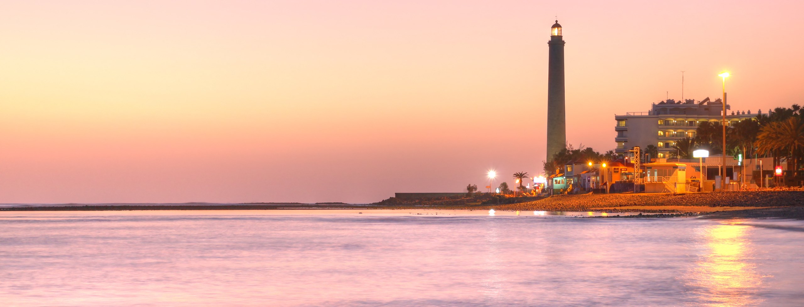
The third largest and second most populated of the Canary Islands, Gran Canaria is a fascinating vacation destination, both for its many manmade and historical features, as well as for its varied landscapes and climate zones – it’s sometimes called a “miniature continent.” Whether by sea or air, almost everyone arrives in the capital of Las Palmas, a cosmopolitan city with a population of some 385,000 – the 9th largest city in all of Spain. Just steps away from the many hotels, restaurants, shops, museums, theaters and churches, is the beach of Playa de las Canteras with its golden sand and great waves for surfers. You’ll also want to enjoy a stroll through the old town known as Vegueta with its picturesque cobblestone streets, as well as a house claimed to be where Columbus spent some time when sailing to and from the New World on his first voyage. True or not, Columbus definitely stopped at the Canaries during his voyages and this house is a museum dedicated to him and his time on the islands. Vegueta is also very popular for its lively bar and music scene.
Gran Canaria is ringed with many fine beaches especially along the southern coast. Along the south there are also extensive sand dunes and beaches on the coast of Maspalomas, as well as the picturesque port towns of Puerto Rico and Puerto de Mogan, the latter of which is better known as “little Venice” because of its canals. Heading southwest from Las Palmas you’ll first come to the town of Tafira, the jump-off point for an excursion to the Caldera de Bandama, which is a vestige of the Canary Islands’ volcanic origins. From here proceed further southwest and then cut northwest inland to Teror. Relatively isolated, reached only by steep winding roads, Teror is nevertheless well known to all Gran Canarians because its basilica is home to the Virgen del Pino – the island’s patron saint. Continue further south and inland, almost at the geographic center of the island, to the town of Tejeda – here you’ll be rewarded with view of the Pico de las Nieves. Just 3 kms south of Tejeda is one of Gran Canaria’s landmarks, the Roque Nublo, an 80-meter (262 ft) high volcanic monolith sitting in a lunar landscape.
From Tejeda head southeast toward the coast and arrive at the town of Aguimes – a town deliberately restored to retain its traditional buildings and atmosphere. At the nearby Barranco de Guayadeque with its lovey palm groves, enjoy the old caves that were once inhabited and today house restaurants. Continue up and around the southwestern coast to Agaete and its harbor, but just before stop at Puerto de las Nieves that offers a fine beach and a spectacular sunset view. Your last stop before heading back to Las Palmas is Galdar, located on the northwestern most promontory. Its beach is well known among scuba-divers, but others may prefer the nearby archaeological area and its museum of the Cueva Pintada or “Painted Cave” devoted to the pre-European Guanches. Although this entire route totals some 315 miles/500 kms and requires at least a couple of days, anyone of these locales can be visited as a one-day excursion from Las Palmas.
Route 3: Fuerteventura
Fuerteventura is the second largest of the Canary Islands and is sparsely inhabited for the same reason that visitors are drawn here – its natural resources are its main attraction; so much so that UNESCO has declared the entire island a Biosphere Reserve. The island does of course offer tourist facilities including hotels, restaurants, and an airport, and the modest capital of Puerto del Rosario doesn’t pressure its visitors to seek out churches, mansions or museums. Fuerteventura is for those seeking beaches, water sports, and unusual aspects of natural history. The climate is mild and it is actually often referred to as “the island of eternal spring.” Although it can sometimes get quite windy, this has translated into something positive for the island as it attracts windsurfers and kitesurfers; the international championship competitions for these two sports are held here each year on the beach of Playas de Sotavento. Conventional surfboarding is of course popular at the 150 beaches along the coast of this long narrow island.
Many visitors agree that the finest of Fuerteventura’s beaches is Playas de Sotavento along the southeastern coast; it is so long that there is room for everyone from surfers to nudists, and swimmers to beach walkers. Scuba divers also find Fuerteventura highly attractive, the most frequented beach being Playa del Matorral along the southeastern tip and the area between Corralejo, a town at the northern tip, and Isla de Lobos, the islet just offshore. Other than beaches, Fuerteventura has a rich natural environment to be explored, and as the oldest of the Canary Islands, for millions of years it has been greatly eroded by wind and weather, exposing large areas of volcanic mountains. The arid and windy climate has also resulted in areas with xerophyte (dry plant) vegetation including succulents, cactus-like euphorbia, acacia, and shrubs off all kinds; some of these plants are shared with Morocco that is only 65miles/100 kms to the east, although many are endemic to Fuerteventura. The island is also home to unusual fauna including rare species of birds such as chat, bustard, and vultures as well as more familiar birds like the collared dove, finches, and swifts; there are also many species of butterflies and moths, as well as ground squirrels and geckos to be seen. Whether chasing waves or butterflies, you will find Fuerteventura has much beauty to offer its visitors.
Route 4: Lanzarote
Lanzarote is the easternmost of the Canary Islands, only some 7 miles/11 kms off the northeast coast of Fuerteventura. Arriving at the island’s capital of Arrecife, this city has two old fortresses that are appealing as well as many beaches along the coast.
The main reason to visit this island is to explore its extraordinary natural phenomena. Like all the Canaries, Lanzarote is a volcanic island with a large section of the southwest designated as the Timanfaya National Park with its 19 sq. miles/50 sq kms of undulating lunar landscape occasionally broken up by crevices and craters. Exploring this national park can happen by marked footpaths, guided tour, and by camel caravans. The lava here dates mainly from eruptions in the 18th century, but it is still so hot below the surface that water poured into select holes spurts up as geysers. Another natural feature that may seem unexpected on volcanic soil is an area with grape vines that yield a very decent wine. Centered around La Geria, about 13 miles/20kms west of Arrecife, many of the vines grow on conventional slopes, although some are cultivated within small, curved stonewall enclosures to protect them from the island’s often strong winds; these vineyards are themselves now protected by UNESCO. If you are interested in wines, then you’ll enjoy a visit to a local winery located in El Grifo and also called “El Grifo.” There is a modest aquarium called Lanzarote Aquarium in the town of Teguise some 15 miles/25 kms north of El Grifo, but perhaps more interesting is a visit to the famous Cactus Garden near Guatiza, along the coast from Arrecife. To bring your day to an end, you may like to visit the caves located up the northern coast. The rare volcanic tunnels of Jameos del Agua, that has interesting subterranean facilities including a restaurant, and Cueva de los Verdes, with its spectacular complex of caves formed by underground lava flows, are truly fascinating and not to be missed.
Route 5: La Palma, La Gomera, El Hierro
La Palma, La Gomera, El Hierro are the three smallest of the Canary Islands. Located the farthest out in the Atlantic Ocean, these islands provide a special experience for those seeking something unique and even a bit exotic. Although each has attractions and facilities that accommodate visitors, it is their geological and other natural features that visitors appreciate.
Like all of the Canaries, these islands are of volcanic origin. La Palma, the largest of the three, has an airport as well as ferry service with the other islands, and undeniably has the most to offer. Its capital, Santa Cruz, has about one-quarter of the island’s 86,000 inhabitants and the usual amenities of a city. Its location exposes it to more rain than the other islands and thus it has lush vegetation. The northern part of the island is dominated by the massive Caldera de Taburiente surrounded by mountains and cut by a canyon and several gorges – it is possible to hike into this caldera which is a national park; the southern part is dominated by a volcanic ridge formed by lava cones, it too can be explored by foot. In some respects more interesting are the many water tunnels that have been cut into the island’s mountains to bring water pipes for the cities and villages and irrigation canals for farms. Tours of these can be arranged in Santa Cruz, but the irrigation canals can easily be seen when driving through the countryside, especially in the Aridane Valley in the west-central part of the island. Another interesting attraction in La Palma are the fifteen telescopes located in internationally maintained observatories along the ridge known as the Roque de los Muchachos at the northern edge of the Caldera del Taburiente. Because of the height here of up to 1,600 meters/5,250 feet and the clear skies – there are no city lights – this area has proven to be an ideal location for astronomers.
La Gomera, just off the coast of Tenerife, seems small enough for a day’s visit by car but its rugged terrain makes that rather challenging. Its main town, San Sebastian, boasts of sites associated with Columbus’ visits there. Those with the time and energy might like to make a trip to the Garajonay National Park, also protected by UNESCO, and hike at least part of the trails that crisscross the slopes of the volcanic mountain; lush vegetation shrouded in clouds and mist are what await you. Those up for a boat ride to the north coast will be amazed to see the famed Los Organos or “Organpipes”, an extraordinary basalt rock formation rising some 800 meters (2,625 ft) out of the sea. If you are lucky, you might hear some native Gomerians demonstrating the whistled language that was once used to communicate and is unique only to this island.
The island of El Hierro is the smallest and westernmost of the Canaries. Considered by the ancients to be the edge of the world, it is now a UNESCO Biosphere Reserve because of its extensive forest and volcanic craters, its natural basins along its coast and its mountain peaks inland. Hike up the mountains to enjoy spectacular views or dip into the crystal clear waters for a refreshing swim, then retire to one of the several picturesque villages like La Frontera, El Pinar, Sabinosa or the island’s capital of Valverde, before concluding your visit to the last outpost of the Canary Islands.
Located off the coast of Africa as they are, it is not surprising that the Canary Islands’ first inhabitants appear to have been related to the Berbers from North Africa; they are known as Guanches and settled on several of the Canaries by approximately 1000 BC. Phoenicians, Greeks, Carthaginians, Numidians (originally from Algeria) and possibly other transient people visited the islands, but did not settle here. The ancients believed that these islands were the westernmost landmass in the world, and they may have inspired the Greek myth of the Fortunate Isles, or Isles of the Blessed, where the especially good would spend their after-life. Starting in the 14th century AD, it is known that sailors from Portugal, Genoa (Italy) and Majorca – Spain’s Balearic Islands – would come ashore here, although none of them established permanent settlements or laid claim to the islands. The Castilian Spanish who came ashore on the island of Lanzarote in 1402 began taking possession of all the islands one by one over the following 93 years. Meanwhile, the Portuguese contested the Spanish for possession of the Canary Islands, but the Pope got the two countries to sign a treaty in 1479 granting Spain sole possession in return for Portugal to obtain the Azores, the Cape Verde Islands, and Madeira.
Christopher Columbus came to the islands in 1492 to stock up on water and provisions and make some repairs before setting off on his momentous first voyage to what he believed would be Asia. He also set off from the Canaries for his following two voyages in order to take advantage of the prevailing northeasterly winds. It was for this same reason that in the decades following Columbus’ epic voyages that Spanish ships carrying the conquistadors, Catholic missionaries, government officials, traders, and of course treasures, passed via the Canaries on their voyages to and from the New World. These ships plus the sugar cane cultivation that the Spanish had introduced here brought considerable prosperity to the islands, in turn attracting international mariners and merchants. This prosperity also led to attacks by Turkish pirates and English raiders in the 16th century as well as by the Dutch army in 1599. In 1797, during the war between Great Britain and Spain, a famous naval battle was fought off of Santa Cruz de Tenerife, as a result of which Spain, once and for all, retained undisputed possession of the Canary Islands.
Since by this time, the Spanish colonies in the Americas were producing sugar cheaper than the Europeans, Spain introduced a new money crop to the Canaries – cochineal, a red dye obtained from the insect of the same name, which they had learned how to make from the indigenous peoples in Mexico. In the 19th century, when synthetic dyes crowded out such natural dyes, the British introduced another cash crop of bananas, but none of these crops were able to support an economy that promised a future for all the islands’ residents. As such, large numbers of residents immigrated to the New World, where their descendants can still be found today in places like Puerto Rico, Venezuela, Louisiana, and San Antonio, Texas.
Among those who remained on the islands were a number of radical leftists, who pushed for independence from Spain, but when the Spanish Civil War broke out in 1936 they could not win against Franco’s forces. Franco maintained strict control of the Canaries, but with his death in 1976 a pro-independence movement did emerge. The movement has never achieved much support among the islanders, the majority of whom find they are quite comfortable identifying as both Canarians and Spanish. The islands’ total population is now approximately 2.1 million, of whom about 1.6 million are native Canarians. Today, tourism has become the single largest contributor to the islands’ economy and each year the Canaries are visited by approximately 12 million visitors.
 View Map

